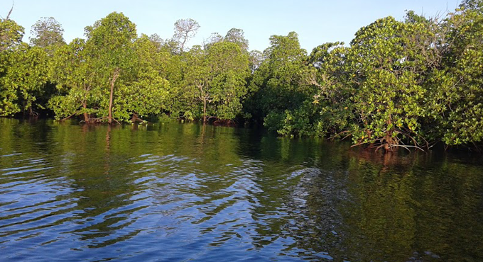

Tanzania houses one of the largest contiguous areas of mangroves in Africa, with forests occurring at the land–sea interface of major river estuaries and deltas along the 1,424 kilometer (km)-long coastline from the border with Kenya in the north to the border with Mozambique in the south. Major river deltas and estuaries include the Rufiji, Ruvuma, Ruvu, Pangani, and Wami rivers. Mangroves are also found along the coasts of the three major islands of Unguja (Zanzibar), Pemba, and Mafia. The Rufiji estuary of Tanzania is one of the two largest mangrove areas in the East African region.
The Rufiji watershed covers about 20 percent of the country’s land area. This area holds numerous tidal channels and multiple creeks where mangroves control the tidal water flow from the Indian Ocean. The Rufiji delta constitutes the most important fishery along Tanzania’s coastline, accounting for about 80 percent of all wild shrimp catch. The Forest Resources Assessment of 2005 provides a list of the full set of mangrove mapping studies carried out in Tanzania since the mid-1960s (see FAO, 2005).. The mangroves in the Rufiji cover three main areas: north Rufiji with the largest mangrove areas, central Rufiji with small mangrove areas, and south Rufiji with half the mangrove area of the north. In a biophysical sense, the delta is in a constant state of transformation with the creation of new channels, sedimentation of old channels, and diversions created by new sand banks. Before 1978, most of the river flowed to the south, but after 1978, the river flow moved northward.
Although East African mangroves have less species diversity than Southeast Asian mangroves, the Rufiji delta possesses the greatest flora and fauna diversity among African mangroves. Tanzania has 10 species of mangroves. The eight most commonly reported ones (with common Kiswahili names in parentheses) are Avicenia marina (Mchu), Bruguiera gymnorrhiza (Mkoko wimbi), Ceriops tagal (Mkoko mwekundu), Heritiera littoralis (Msikundazi), Lumnitzera racemosa (Mkaa pwani), Rhizophora mucronata (Mkoko), Sonneratia alba (Mpira), and Xylocarpus granatum (Mkomafi) . All these species are found in the Rufiji estuary, and they are used for a variety of food, fuel, and other products for both local consumption and income generation. Products include posts and poles for construction and boats, beehives, fuelwood, and charcoal, as well as fruits and roots for medicinal purposes. Mangroves are also home to a large number of fish, particularly juveniles, which provide food and income to local villagers
DRIVERS OF MANGROVE DEFORESTATION AND DEGRADATION
Mangrove timber from Tanzania has been commercially traded since the ninth century, when it was sold to northern non-forested countries, particularly in the Arabian Peninsula. Today, mangrove forests in Tanzania face some pressures from a range of drivers. We can categorize these threats into ecological and socioeconomic causes. Ecological threats to mangroves include floods resulting in water-level alteration, bank erosion, and diversion of water courses; sand deposition from sea and land that cuts off portions of mangrove forests from salt water; and sea-level rise as a result of climate change. Socioeconomic threats across Tanzania include mangrove cutting to obtain fuelwood used for salt production (particularly in Tanga); lime burning (in Bagamoyo, Lindi, and Mtwara) and fish smoking (in Pangani). Mangrove areas are also cleared for salt pans in Tanga, Bagamoyo, and Mtwara. Pole cutting for sale in Dar es Salaam, Zanzibar, and may be beyond is another driver of mangrove deforestation.
In the Rufiji delta, the main drivers of the destruction of mangroves include rice paddy production and prawn farming. In addition, dragging seine nets under mangrove canopies, dynamite fishing, industrial activities, oil pollution, and siltation threaten mangroves. There is also a growing threat of oil palm plantation expansion in the Rufiji through small-scale land leases. Within the Rufiji, in particular, there have been project proposals that have threatened large parts of the mangrove forest
APPROACH TO MANGROVE PROTECTION
Since 1980, the Government of Tanzania and other development actors have undertaken a variety of initiatives to reduce mangrove deforestation and degradation, and to restore, rehabilitate, and preserve mangrove areas. From independence in 1961 until the 1990s, initiatives set into motion by the government mainly focused on strict protection of mangroves for timber production. Since the 1990s, the approach to mangrove protection has changed, with new efforts more focused on collaboratively managing mangroves with local communities. This turn toward community based management was motivated by several challenges that emerged from both the local and national scales. Most recently, there is growing interest in understanding the role of mangroves in terms of their carbon stock pools, ability to sequester carbon, and impact of converting mangroves to other land uses. For example the East Africa Mangrove Carbon Project is being carried out by University of Dar es Salaam, TFS, and the US Forest Service within the Rufiji mangrove research and demonstration forest (9,200 ha). There are likely to be new projects that will provide financing for enhancing carbon pools in mangroves.


